A townland (Irish: baile fearainn) is a small geographical division of land used in Ireland. The townland system is of Gaelic origin, pre-dating the Norman invasion and most have names of Irish Gaelic origin. In Ireland, a townland is (generally) the smallest administrative division of land, though a few large townlands are further divided into hundreds. Whilst the concept of townlands is based on the Gaelic system of land division, it was in the 1600s that they became mapped and defined by the English administration for the purpose of confiscating land and portioning it out to English investors or as grants to English planters.The first official evidence of the existence of this Gaelic land division system can be found in church records from before the 12th century.
Throughout most of Ulster, townlands were known as "ballyboes" (Irish: baile bó, meaning "cow land"), and represented an area of pastoral economic value. The ballybetagh was the territorial unit controlled by an Irish sept, typically containing around 16 townlands. Fragmentation of ballybetaghs resulted in units consisting of four, eight, and twelve townlands. One of these fragmented units, the "quarter" (representing a quarter of a ballybetagh), was the universal land denomination recorded in the 1608 survey for County Donegal. In the early 17th century, 20% of the total area of western Ulster was under the control of the church. These "termon" lands consisted likewise of ballybetaghs and ballyboes, but were held by erenaghs instead of sept leaders.
The average area of a townland is about 325 acres (132 ha), but they vary widely in size.The ballyboe was described in 1608 as containing sixty acres of arable land, meadow, and pasture; however, this was misleading as the size of townlands under the Gaelic system varied depending upon their quality, situation, and economic potential. This economic potential ranged from the extent of land required to graze cattle to the land required to support several families.The highest density of townland units recorded in Ulster in 1609 corresponds to the areas with the highest land valuations in the 1860s. It seems that many moorland areas were not divided into townlands until fairly recently. These areas were "formerly shared as a common summer pasturage by the people of a whole parish or barony".
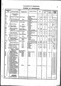
Until the 19th century, most townlands were owned by a single person and occupied by multiple tenants. The cess, used to fund roadworks and other local expenses, was charged at the same rate on each townland in a barony, regardless of its size and productive capacity. Thus, occupiers in a small or poor townland suffered in comparison to those of larger or more fertile townlands. This was reformed by Griffith's Valuation. During the 19th century, an extensive series of maps of Ireland were created by the Irish division of the Ordnance Survey for taxation purposes, which documented and standardised the boundaries of the more than 60,000 townlands in Ireland. This process often involved dividing or amalgamation of existing townlands, and defining townland boundaries in areas such as mountain or bog land that had previously been outside the townland system. Slight adjustments are still made; there were 60,679 in 1911 compared to 60,462 townlands in 1901.
A parish is a church territorial unit constituting a division within a diocese. A parish is under the pastoral care and clerical jurisdiction of a parish priest, who might be assisted by one or more curates, and who operates from a parish church. Historically, a parish often covered the same geographical area as a manor (its association with the parish church remaining paramount). By extension the term parish refers not only to the territorial unit but to the people of its community or congregation as well as to church property within it.In the Roman Catholic Church, each parish normally has its own parish priest, who has responsibility and canonical authority over the parish. The Irish civil parish was based on the Gaelic territorial unit called a túath orTrícha cét. Following the Norman invasion of Ireland, the Anglo-Norman barons retained the tuath, later renamed a parish or manor, as a unit of taxation. The civil parish was formally created by Elizabethan legislation. Accounts were kept of income and expenditures for each parish including pensions and poor relief. Statutes were based on ecclesiastical parishes, although it is not known how well-defined such parishes were.
Divisions originated as subdivisions of poor law unions, grouping a number of townlands together to elect one or more members to a Poor Law Board of Guardians. The boundaries of district electoral divisions were drawn by a Poor Law Boundary Commission, with the intention of producing areas of roughly equivalent "rateable value" (the total amount of rates that would be paid by all ratepayers in the Division) as well as population. This meant that while Divisions were almost always contiguous, they might bear little relation to natural community boundaries.
Townland Search
The information on this website is free and will always be so. However, there are many documents and records that we would like to show here that are only available for sale. If you would like to make a donation to the Lurgan Ancestry project, however small (or large!), to enable us to acquire these records, it would be very much appreciated.
What Records are Available
This website is dedicated to the Sons and Daughters of Lurgan down through the ages.